WRLD

Aggregated public profile · Not an official account.

🌧️⛈️Profesor Eduardo ( The Weatherman) 🌨️🌪️

@EdoWeatherman wrld.org

Eduardo, known as The Weatherman, wrote that between today and Friday, instability would persist from Illapel to Los Lagos, with periods of heavy downpours and possible thunderstorms, hail, and gusty winds. He warned that these phenomena would be sectorized and intermittent, and noted that the most intense conditions would be recorded between the Metropolitan Region and Los Lagos. He also asked his followers to report on the conditions in their areas. #Clima #Tormentas #Inestabilidad (translated)

3054

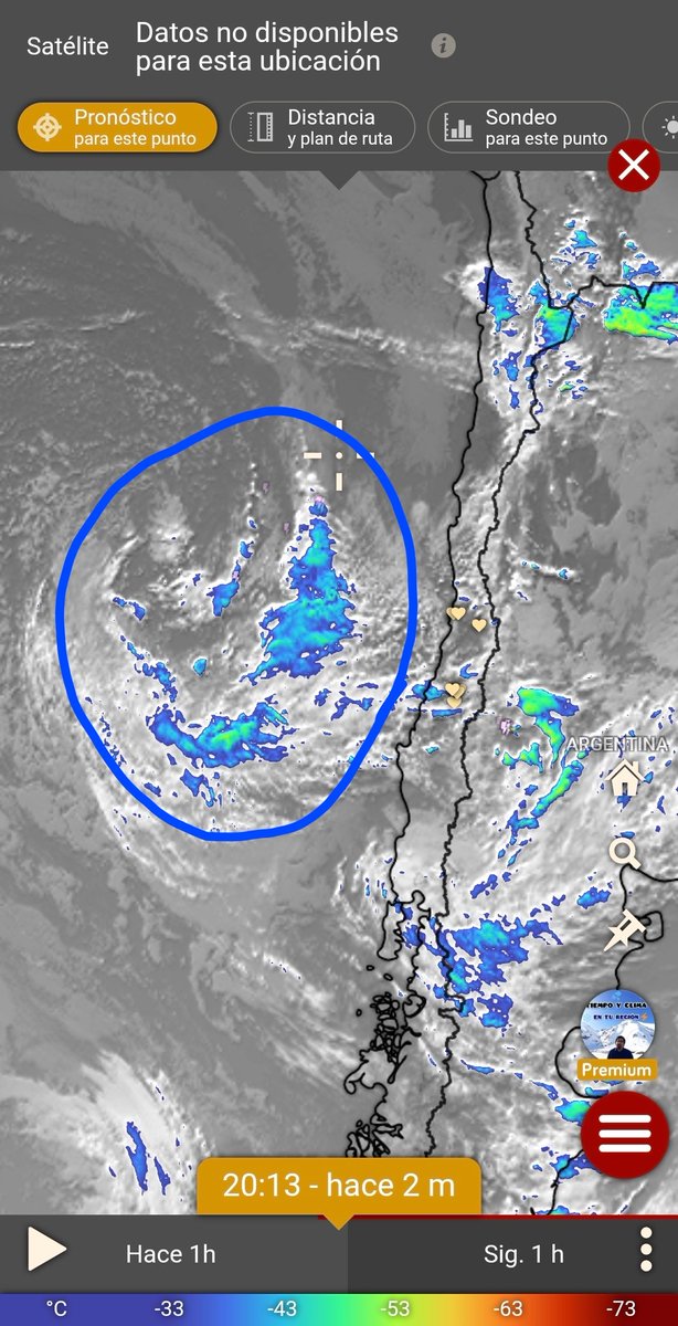
Professor Eduardo, known as The Weatherman, warned that in the coming hours powerful cumulonimbus clouds were expected from the ocean, with thunderstorms, rain, wind, and hail in various regions of the central and southern areas. He added that the phenomenon could also reach part of southern Coquimbo and that flash flooding could occur. He invited his followers to leave their reports in the comments. #Clima #Tormentas #Inundaciones (translated)

3284

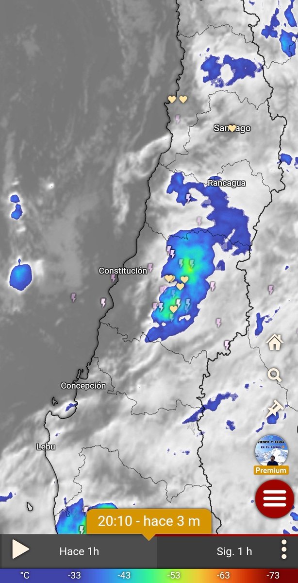
Professor Eduardo (The Weatherman) indicated that there was a large amount of storms on the coast of Maule and asked to stay alert during the next few hours. https://t.co/R4trkxAzkc #Tormentas #Maule #Clima (translated)

2944

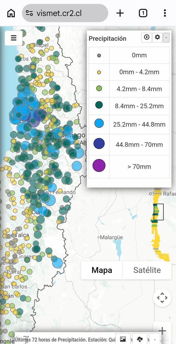
Eduardo, known as The Weatherman, pointed out that the forecast had been met, although the storms had affected specific areas and some people had reported little rain or a lack of electrical activity. He indicated that episodes of intense rain and hail had been recorded, especially in areas of the regions of Valparaíso, Metropolitan, and O’Higgins, where some localities had already surpassed 40-50 mm. In contrast, he stated that little water had fallen from Maule southward. He also warned that several thunderstorms and intense rain bursts were expected until Friday, with significant precipitation from Maule southward and also in the central area. He then asked his followers to comment on how the situation was in their areas. #Tormentas #Clima #Emergencias (translated)

3058

Professor Eduardo, known as The Weatherman, reported that the storms were multiplying in the central area and that intense convective activity was still present. He warned of a high risk of flash floods and landslides, and asked his followers to comment on how the situation was in their areas. https://t.co/BZUafiNjUn #tormentas #inundaciones #clima (translated)

3060

Eduardo, known as The Weatherman, reported that thunderstorms had already been recorded in parts of the central area and that more were expected. He noted that the most intense part of the day would occur in the afternoon between sectors of Coquimbo and part of Los Ríos, with heavy downpours, storms, hail, strong winds, and the risk of sudden floods and landslides. He also indicated that tornadic clouds could form in the south-central area and reminded that thunderstorms would affect localized areas. Additionally, he asked his followers to comment on the situation in their sectors. #Tormentas #Clima #Emergencia (translated)

2949

Professor Eduardo, known as The Weatherman, pointed out that storms were starting to develop in the Metropolitan Region and part of O'Higgins, and that several more were on the way. He also asked his followers to share their reports in the comments. https://t.co/M0l7w0245Q #Tormentas #Meteorología #RegiónMetropolitana (translated)

3176

Professor Eduardo, known as The Weatherman, reported that electrical activity was already being recorded in some areas of O'Higgins and that powerful clouds were advancing over the ocean. He added that in the next few hours, the storms would be multiplying. (translated)

3065

Professor Eduardo (The Weatherman) warned of an intense storm that, as he wrote, was expected from this Tuesday between Coquimbo and parts of Los Ríos, with downpours, thunderstorms, hail, and gusts of wind. He attributed the phenomenon to a low pressure that could generate storms for several hours. He also indicated that the isotherm would not drop below 2,500 meters above sea level and that periods of heavy rain would be recorded, which he considered to pose a very high risk of sudden floods and landslides. According to the author, the greatest intensity was projected between the Metropolitan Region and Biobío, and some areas could accumulate more than 80 mm during those days. He added that instability would continue until Saturday in the central and southern regions, that there were already indications of another event for the following week, and that storms could be recorded that same night in areas of the central zone. #tormenta #alerta #clima (translated)

3293

Professor Eduardo reported that at that time the first thunderstorms were being reported in sections of the central area and noted that they would be a precursor to what would happen in the coming days. He also asked his followers to comment on the situation in their areas. https://t.co/BBSgOm1yxT #Tormentas #Clima #ZonaCentral (translated)

2959

Professor Eduardo (The Weatherman) warned of a period of instability between this Monday and Friday in Norte Chico, the central area, and part of southern Chile, up to Los Lagos. According to what he wrote, heavy rains, thunderstorms, hail, and moderate winds were expected, with the most storm activity forecasted for Tuesday, Wednesday, and Thursday. The author noted that the risk of sudden floods would be very high and that there was also a high possibility of mudslides, as the isotherm would be located between 2500 and 3000 meters above sea level, and could even rise further. He added that the system could cause more damage and complications than previous events. Regarding precipitation, he indicated that some areas could accumulate 20-45 mm and others could exceed 70-90 mm. He identified the interior between the Metropolitan and Biobío regions as the stretch with the highest likelihood of significant amounts, with places potentially exceeding 100 mm and registering periods of more than 10 mm per hour during the storms. He characterized the event as extreme for October and called for preparedness. #InestabilidadClimática #RiesgoDeInundaciones #TormentasSeveras (translated)

3415

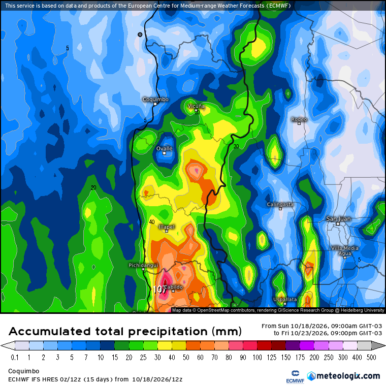
Professor Eduardo (The Weatherman) warned that a period of intense instability, which he said would last from Monday to Friday, would affect the region from Coquimbo to Los Lagos. He pointed out that a low-pressure system could cause rain of varying intensity, strong thunderstorms, hail, and wind; he also mentioned possible precipitation in parts of Atacama and strong winds in the northern region. Describing a projection from the European model ECMWF on Wibdy, he indicated that between Tuesday and Wednesday some areas could receive more than 20 millimeters of rain and others more than 50. He added that for Thursday and Friday, another round of precipitation and storms was expected, with cores that, as he explained, pointed to the potential for severe storms and hail. Eduardo stated that the number of storms posed a very high risk of sudden flooding and a high likelihood of landslides, due to the isotherm being situated between 2,500 and 3,000 meters above sea level, or even a bit higher. He warned that the episode could cause more complications and damage than recent events and that it could still intensify, so he urged people to prepare. #Inestabilidad #Tormentas #Clima (translated)

3079

Professor Eduardo (The Weatherman) warned about a low-pressure system that, as he projected, would affect areas between Coquimbo and Los Lagos from Monday to Thursday, with variable intensity precipitation, thunderstorms, hail, and wind. He said there would be breaks with sun and clouds and that the rainfall would be uneven, with greater accumulations in inland and mountainous areas. The author warned of possible intense storms and downpours in the central region and noted that he could not specify where they would occur because, as he wrote, there were no radars. He also indicated that the risk of flash floods would be very high, especially on Tuesday and Wednesday, and that there was a high possibility of landslides due to the isotherm being positioned between 2,500 and 3,000 meters above sea level, or even higher. He estimated that accumulations could vary between 20 and 40 millimeters in some areas and exceed 70 to 90 millimeters in others, mainly between Coquimbo and Biobío. He added that the system could cause more damage and complications than recent events, that it could intensify, and that it would not be the last episode of the month. He announced a new update for the following day. #Clima #Tormentas #Inestabilidad (translated)

2971

Eduardo, known as The Weatherman, noted that the models maintained the projection of a period of instability between Monday and Wednesday of next week in the Norte Chico, the central zone, and the south. He indicated that it would not rain continuously, but that episodes of intense precipitation and convective activity were expected. He also warned that at times, the isotherm would be situated between 2,800 and 3,100 meters above sea level, which, as he wrote, could cause floods. He added that the event would affect from Atacama to part of Los Lagos, while further north strong winds and possible sandstorms were expected. He said he would share an update the next day. #Clima #Pronóstico #Aluviones (translated)

2975

Professor Eduardo, known as The Weatherman, reported that he was closely monitoring an event with the potential for severe storms and a high risk of flooding in Northern Chico and the central area of Chile. According to what he wrote, a low pressure system would be stationary in front of the center of the country between Monday and Thursday of next week, favoring a prolonged period of instability, with precipitation, wind, possible thunderstorms, and hail between Coquimbo and Los Ríos. He indicated that the rains would be intermittent, with pauses and episodes of intense precipitation and storms. He also noted that the isotherm would be around 2500-2900 meters above sea level and that the accumulated amounts would average 20-40 mm. In interior areas between Coquimbo and Ñuble, he added, storms could leave more than 50-70 mm in less than 6 hours. He said he would update the information. #ClimaChile #Tormentas #Aluviones (translated)

3324

Professor Eduardo, known as The Weatherman, said he would take on the task of informing the authorities. He wrote that the next day and Thursday, some storms could develop in inland areas of the central zone, although with less potential and without reaching the intensity recorded that day. He also warned of a significant instability event that, between the following Monday and Wednesday, could affect areas from Coquimbo to the southern region and cause damage and strong storms. #Clima #Tormentas #Inestabilidad (translated)
3098

Professor Eduardo (The Weatherman) indicated that a powerful cloud was advancing towards Talca and warned that heavy rains could return, along with thunderstorms and hail. https://t.co/8jDeEZjg6y #Talca #Clima #Tormentas (translated)

2984

Professor Eduardo, known as The Weatherman, noted that at that moment the storms were concentrated in areas of the Maule region and that instability still persisted. He indicated that they were also likely in the central area the following day and warned that a more stormy event could occur the following week. In addition, he asked his followers to share their reports. https://t.co/9SFN6zets0 #Tormentas #Clima #Maule (translated)

3099

Professor Eduardo reported that the intense thunderstorm started in Talca after 15:20 and shared a recording from his camera. He also described a large amount of rain and hail. https://t.co/A5nqGFKeGy #Tormenta #Talca #Clima (translated)

2984

Professor Eduardo (The Weatherman) pointed out that, as he had announced, thunderstorms had begun. He indicated that today they would be concentrated in the south, especially in La Araucanía, and in some areas of North Chico, while they were likely in the central zone. He also asked his followers to leave their reports in the comments. https://t.co/CVzTHbOpwZ #Tormentas #Clima #LaAraucanía (translated)

2988