BETA nonprofit public democratic european moderated

ValènciaWeather⚡️

8 posts

ValènciaWeather⚡️

Mentions and quotes

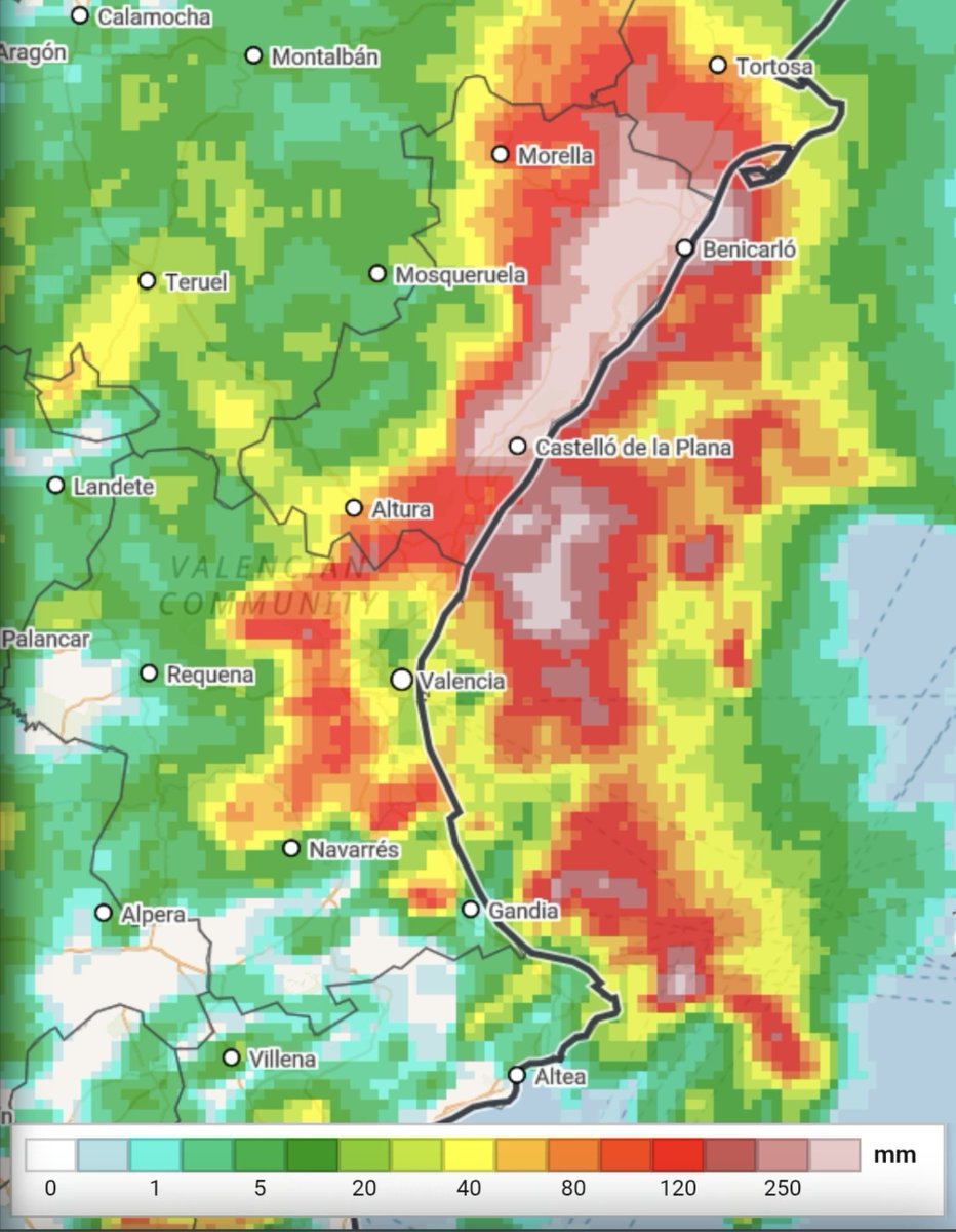
The usual critiques are already starting, so it's worthwhile to put on the table how meteorological science works in an episode like this. The numerical models showed a clear scenario of irregular but high-impact storms. In this configuration, the key is not that it rains everywhere equally, but the danger where storms form and barely move: torrential intensities (>90 mm/1h) and critical accumulations (>180 mm/12h). We don't work with a crystal ball; we work with supercomputers that solve millions of mathematical equations to project the future atmosphere. Why is it so complex to specify the exact municipality? Unlike a winter storm with continuous and organized fronts, the physics of these storms is much more complex. They depend on how winds collide on a microscale, humidity, and relief over just a few kilometers. They do not follow a rigid pattern: they move and regenerate where that flow collision occurs, and modeling that to the millimeter is a huge challenge. Science always has room for improvement, of course. But before blaming meteorologists and @AEMET_Esp, it's worth remembering the rigor and constant vigilance behind issuing warnings that save lives. #Meteorología #Ciencia #Clima (translated)
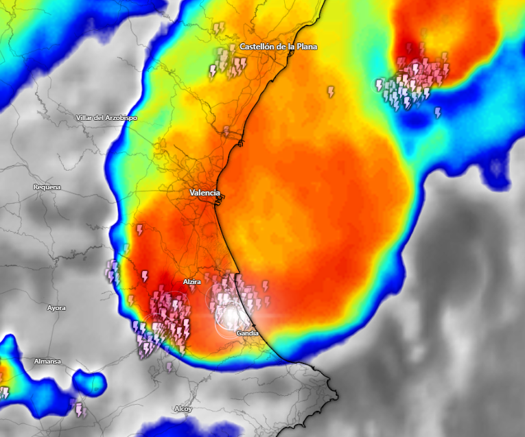
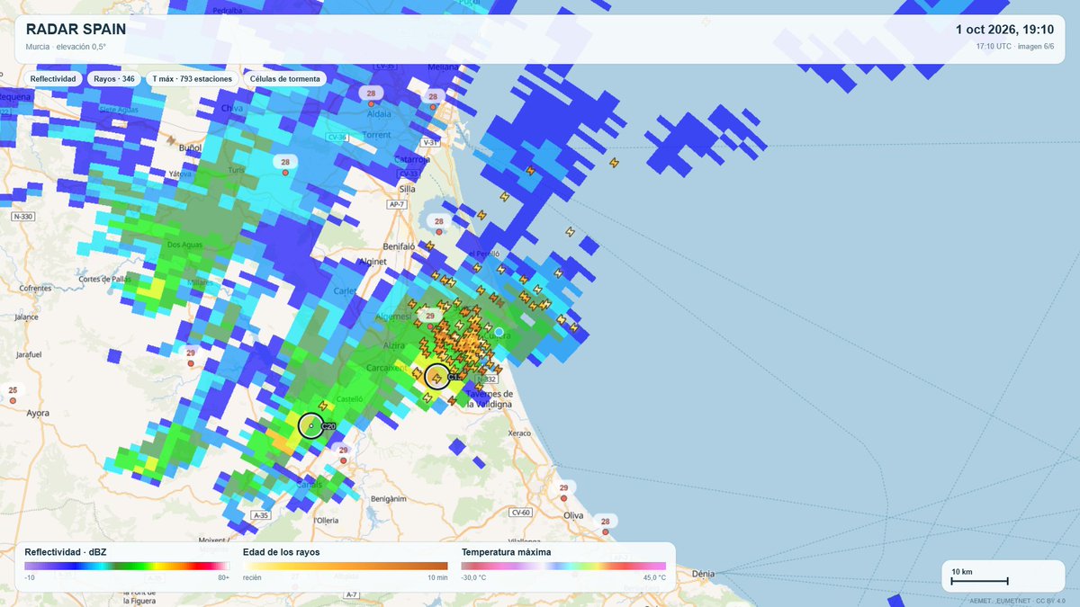
Brutal convective system right now. Its most active part currently affecting the south of Valencia. https://t.co/9Cqsnkqthc #Clima #Valencia #Meteorología (translated)

Although some are already complaining that it doesn't rain in Valencia, not everything is the capital. Very adverse storms are being recorded in different areas, with significant amounts of precipitation in very short periods of time. We already warned that it would be a particularly complex episode: the high danger adds to the impossibility of predicting exactly where the most intense cores will discharge. Example now the core of the image. #Valencia #Tormentas #Clima (translated)

We informed 48 hours in advance. Very dangerous situation, we insist not because of the event itself, but because of its uncertainty. They will be irregular storms but very adverse with exceptional rainfall intensities. Please be careful in the next 24 hours, starting practically NOW. https://t.co/TBGIP9Hl4H #Tormentas #Clima #Advertencia (translated)

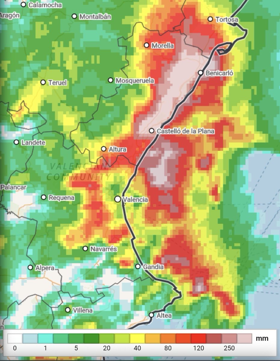
⚠️ATTENTION AFFECTED AREAS DANA 29-O⚠️ ➡️Although this situation is of high danger, it is not a scenario in any way similar to 29-O. The most intense rainfall will be in a much smaller area, closer to the coast and of shorter duration, thus reducing the risk of river and ravine overflow. 🚨The risk will be rainfall flooding (the drainage system is not capable of handling the rainwater) but maintaining the risk (with lower probability) of some local overflow, especially in the NORTH OF CASTELLÓN where the rainfall may be more intense inland. ⚠️Even so, we repeat that this is a situation of much uncertainty and difficult forecasting. There is a possibility that storms may occur at sea or with greater or lesser intensity than predicted. The red alert is CORRECT from AEMET. 📲🔴About the Es-Alert: it has been used to notify of the red alert that comes into effect from 18:00 and ends at 1:59 on Friday. In this tweet, we will not comment on its use; we will leave that for after the episode. 🗺Map: Accumulated precipitation in 12h https://t.co/A6YUIBXlF2 https://t.co/A6YUIBXlF2 #Dana29O #Inundaciones #Clima (translated)

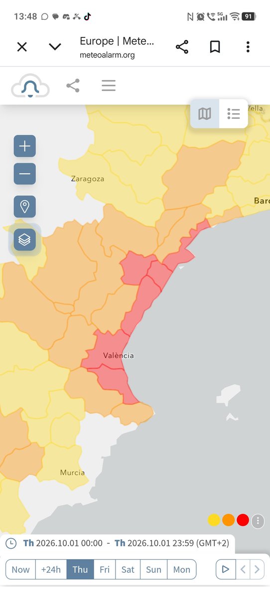
Ante el revuelo y la desinformación en redes y medios sobre el episodio de lluvias en Valencia, conviene poner los datos sobre la mesa con rigor: 🔴 El aviso rojo no es subjetivo Exige rebasar umbrales técnicos estrictos (>90 l/m² en 1 h o >180 l/m² en 12 h) que no se alcanzaron en los observatorios oficiales. El nivel naranja estuvo meteorológicamente bien tipificado. 🎯 Basta de señalar el trabajo de AEMET Es incomprensible el ataque mediático hacia los meteorólogos. AEMET cumplió con su labor técnica, anticipando y activando el aviso naranja con entre 12 y 24 horas de antelación: margen más que suficiente para que tanto la población como Protección Civil pudieran prepararse. Disparar contra la previsión oficial es buscar culpables donde no los hay. 🟠 Aviso naranja = Peligro importante No es un trámite menor. Implica un riesgo real y conocido con antelación suficiente. Mantener la convocatoria de un partido de fútbol y movilizar a miles de aficionados hacia el estadio bajo este escenario es una absoluta irresponsabilidad y una situación lamentable que pone en riesgo innecesario a las personas. No se debió esperar al último momento sobre el césped para frenar ese desplazamiento masivo. 📲 Uso y optimización de ES-Alert El envío de alertas masivas al móvil corresponde a Protección Civil, no a AEMET. El ES-Alert llegó con excesivo retraso; es una herramienta que debe optimizarse. Con un aviso naranja ya activo, la alerta ciudadana debió emitirse en cuanto el radar constató que una tormenta potencialmente peligrosa se aproximaba de lleno a una urbe con la densidad de población de Valencia, evitando desplazamientos a tiempo y no cuando el impacto ya era inminente. Menos alarmismo interesado y más rigor con la ciencia y los protocolos de emergencia. Mapa de https://t.co/RITZseIgyF. #Valencia #AEMET #Emergencia

Aquí la cosa es, teniendo un aviso naranja y viendo que era obvio que iba a ocurrir esto por que llevamos avisando desde ayer. Por qué se ha hecho el partido igualmente generando movilizaciones innecesarias? #AvisoNaranja #Movilizaciones #Seguridad

Las tormentas están siendo muy adversas. Mucho cuidado. La tormenta se desplazará muy lentamente y dejará grandes cantidades de lluvia. https://t.co/dZTCAhWDk5 #Tormentas #Clima #Lluvias