WRLD

Search

#Coquimbo

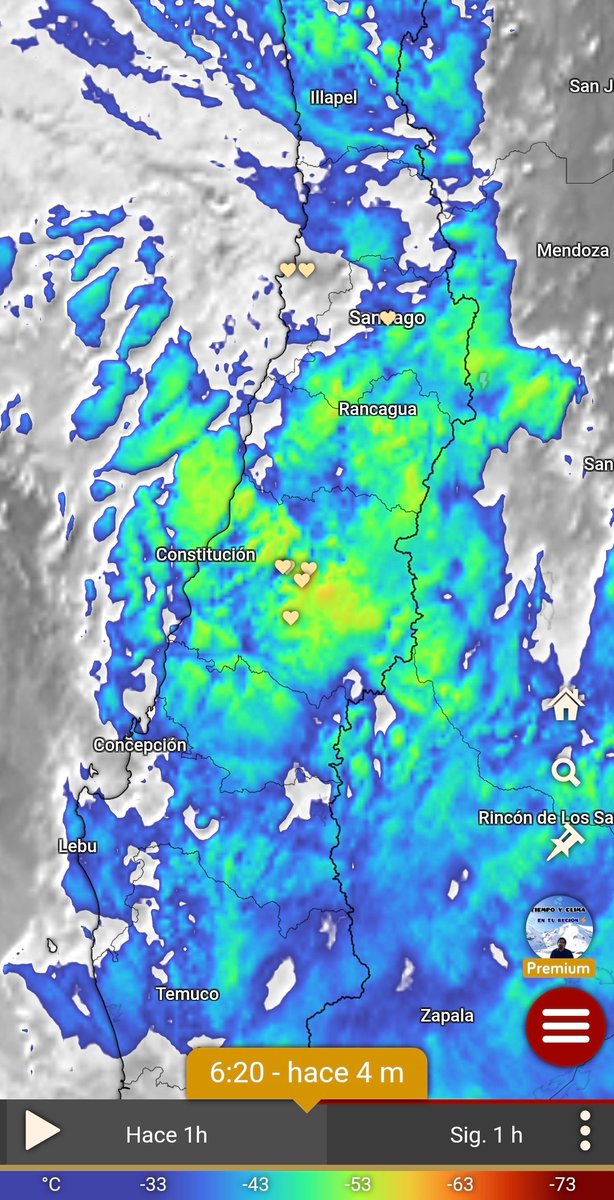
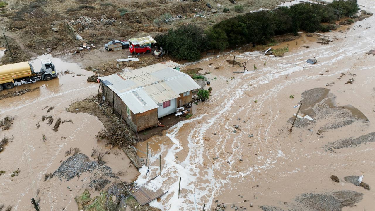
Professor Eduardo (The Weatherman) warned of a period of instability between this Monday and Friday in Norte Chico, the central area, and part of southern Chile, up to Los Lagos. According to what he wrote, heavy rains, thunderstorms, hail, and moderate winds were expected, with the most storm activity forecasted for Tuesday, Wednesday, and Thursday. The author noted that the risk of sudden floods would be very high and that there was also a high possibility of mudslides, as the isotherm would be located between 2500 and 3000 meters above sea level, and could even rise further. He added that the system could cause more damage and complications than previous events. Regarding precipitation, he indicated that some areas could accumulate 20-45 mm and others could exceed 70-90 mm. He identified the interior between the Metropolitan and Biobío regions as the stretch with the highest likelihood of significant amounts, with places potentially exceeding 100 mm and registering periods of more than 10 mm per hour during the storms. He characterized the event as extreme for October and called for preparedness. #InestabilidadClimática #RiesgoDeInundaciones #TormentasSeveras (translated)
1473

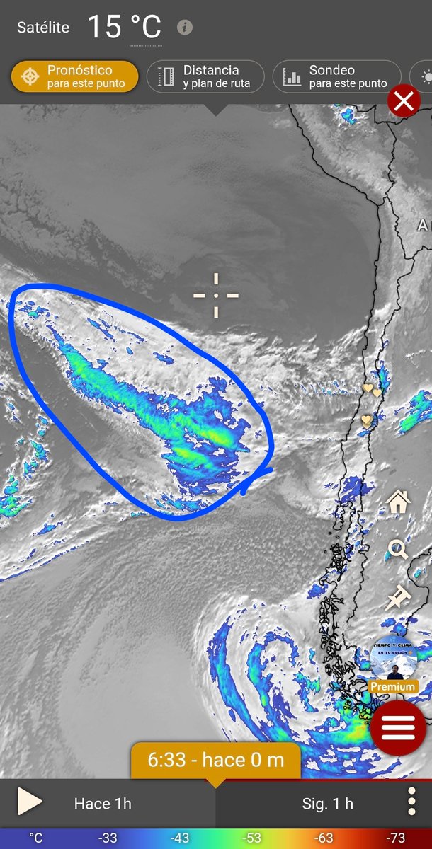
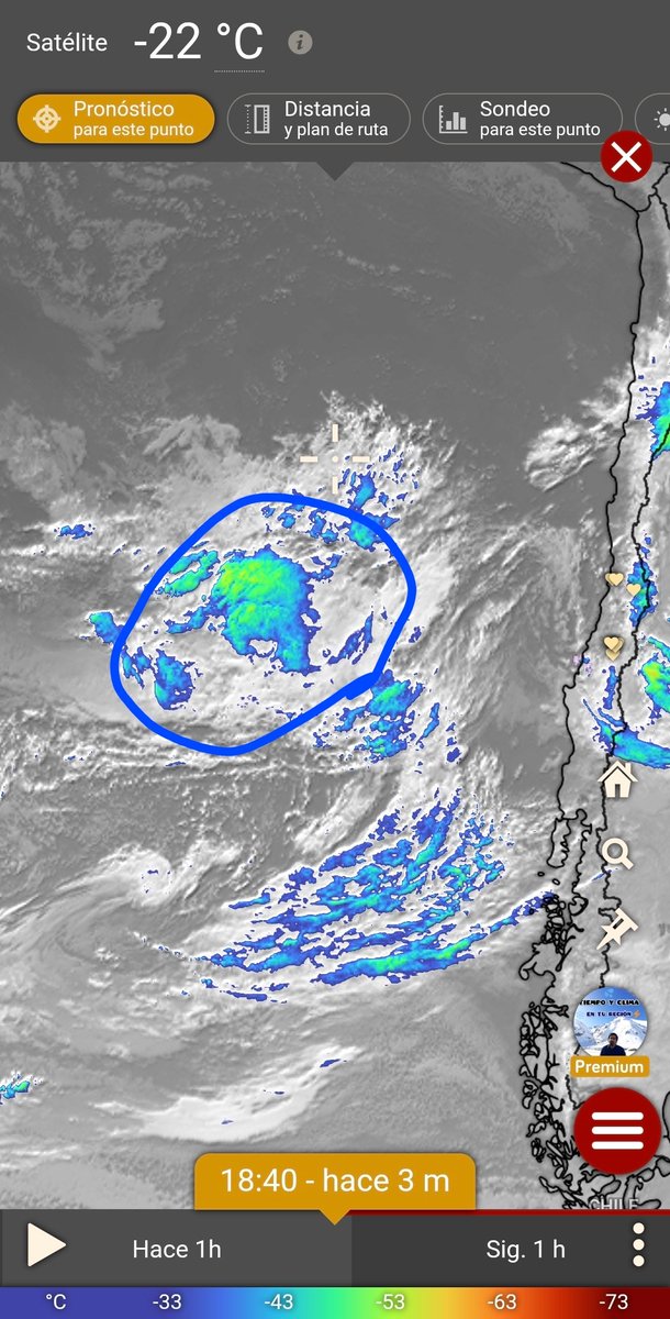
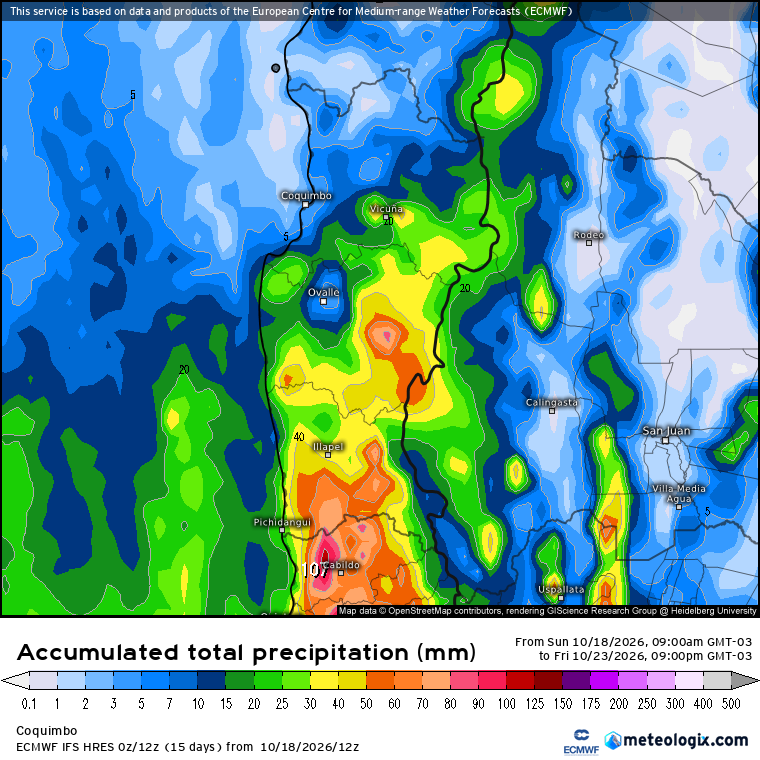
Professor Eduardo (The Weatherman) warned that a period of intense instability, which he said would last from Monday to Friday, would affect the region from Coquimbo to Los Lagos. He pointed out that a low-pressure system could cause rain of varying intensity, strong thunderstorms, hail, and wind; he also mentioned possible precipitation in parts of Atacama and strong winds in the northern region. Describing a projection from the European model ECMWF on Wibdy, he indicated that between Tuesday and Wednesday some areas could receive more than 20 millimeters of rain and others more than 50. He added that for Thursday and Friday, another round of precipitation and storms was expected, with cores that, as he explained, pointed to the potential for severe storms and hail. Eduardo stated that the number of storms posed a very high risk of sudden flooding and a high likelihood of landslides, due to the isotherm being situated between 2,500 and 3,000 meters above sea level, or even a bit higher. He warned that the episode could cause more complications and damage than recent events and that it could still intensify, so he urged people to prepare. #Inestabilidad #Tormentas #Clima (translated)

2425

Professor Eduardo (The Weatherman) warned about a low-pressure system that, as he projected, would affect areas between Coquimbo and Los Lagos from Monday to Thursday, with variable intensity precipitation, thunderstorms, hail, and wind. He said there would be breaks with sun and clouds and that the rainfall would be uneven, with greater accumulations in inland and mountainous areas. The author warned of possible intense storms and downpours in the central region and noted that he could not specify where they would occur because, as he wrote, there were no radars. He also indicated that the risk of flash floods would be very high, especially on Tuesday and Wednesday, and that there was a high possibility of landslides due to the isotherm being positioned between 2,500 and 3,000 meters above sea level, or even higher. He estimated that accumulations could vary between 20 and 40 millimeters in some areas and exceed 70 to 90 millimeters in others, mainly between Coquimbo and Biobío. He added that the system could cause more damage and complications than recent events, that it could intensify, and that it would not be the last episode of the month. He announced a new update for the following day. #Clima #Tormentas #Inestabilidad (translated)

2887

Professor Eduardo, known as The Weatherman, reported that he was closely monitoring an event with the potential for severe storms and a high risk of flooding in Northern Chico and the central area of Chile. According to what he wrote, a low pressure system would be stationary in front of the center of the country between Monday and Thursday of next week, favoring a prolonged period of instability, with precipitation, wind, possible thunderstorms, and hail between Coquimbo and Los Ríos. He indicated that the rains would be intermittent, with pauses and episodes of intense precipitation and storms. He also noted that the isotherm would be around 2500-2900 meters above sea level and that the accumulated amounts would average 20-40 mm. In interior areas between Coquimbo and Ñuble, he added, storms could leave more than 50-70 mm in less than 6 hours. He said he would update the information. #ClimaChile #Tormentas #Aluviones (translated)

3258

Professor Eduardo, known as The Weatherman, said he would take on the task of informing the authorities. He wrote that the next day and Thursday, some storms could develop in inland areas of the central zone, although with less potential and without reaching the intensity recorded that day. He also warned of a significant instability event that, between the following Monday and Wednesday, could affect areas from Coquimbo to the southern region and cause damage and strong storms. #Clima #Tormentas #Inestabilidad (translated)

3045
Colo-Colo 7d

Colo-Colo presented its starting lineup for the Primera MercadoLibre League match against Coquimbo Unido and indicated that the lineup was presented by Jugabet. https://t.co/gfts6HEmAe #LigaDePrimera #Fútbol #Deportes (translated)

3066
Daniel Manouchehri 1w

Daniel Manouchehri pointed out that the Government had announced a disaster zone in Las Condes within hours, while in Coquimbo the state of catastrophe came six days later, when deaths had already been counted. He stated that the Government valued the lives of the inhabitants of Coquimbo less than those of their neighbors in Las Condes and requested the same urgency for the regions, although he expressed happiness for the people of Las Condes. #Catástrofe #Igualdad #Regiones (translated)

2965

Professor Eduardo (The Weatherman) reported that, at that hour, there were intense rains from the O'Higgins regions southward and that the precipitation was advancing northward. He noted that in the afternoon, very intense rains were expected in the Valparaíso and Metropolitan regions, as well as heavy precipitation in the south of Coquimbo. He also indicated that gusts of wind of more than 35-50 km/h were being recorded and invited comments on the situation in each sector. #ClimaChile #Lluvias #PronósticoMeteorológico (translated)

2981
Chilean Premier League Sep 6

NOCHE AZUL Con goles de Vargas, doblete de Lucero, y uno del retornado Octavio Rivero Universidad de Chile derrotó a Coquimbo y se mantiene en pelea por los cupos de Libertadores. https://t.co/xHTncH6jD8 #fútbol #Chile #Libertadores

11947
cris Aug 20

River jugó un PT regular, dónde si apretaba un poco más podía llegar a hacer un gol. El segundo tiempo Eduardo Coudet hizo los peores cambios de la historia y nos tiró atrás como si fusemos Coquimbo Unido. Es desastrozo lo del dt de River, hoy hizo todo lo posible para perder. #RiverPlate #Futbol #Coudet

18023
Palermista🇸🇪 Aug 20

🔥🔥 HISTÓRICO 🔥🔥 EL PLATENSE DE MARTÍN PALERMO ACABA DE ELIMINAR A COQUIMBO UNIDO POR LOS 8VOS DE FINAL DE LA COPA LIBERTADORES DE AMÉRICA🏆 VA A JUGAR 4TOS DE FINAL POR PRIMERA VEZ EN SU HISTORIA VS FLUMINENSE🇧🇷 FELICITACIONES MARTÍN! TUS ALEGRÍAS SON LAS NUESTRAS 🦑🟤⚪ https://t.co/OlBgrs1wug #CopaLibertadores #Platense #Fútbol

14961

Proyección en seguimiento. Abundantes lluvias retornarían a Chile central. Días atrás publiqué que la zona central tendría una semana sin lluvias, una tregua pasajera, esto porque durante la próxima semana volverían las lluvias, el viento y las tormentas eléctricas. He estado siguiendo estos posibles eventos y puedo decirles que deben estar atentos, un patrón favorable para recibir una serie de eventos de lluvia podría constituirse desde el 24 de agosto en adelante. Diversos modelos ya muestran señales preocupantes, con sectores que fácilmente acumularían más de 100-150 mm en este nuevo tren de sistemas frontales. Como señalo en el título de esta publicación, esta proyección se encuentra en seguimiento y se estará actualizando los próximos días, pero es prudente estar atentos. De momento los sectores afectados abarcarían el tramo entre la region de Coquimbo y Los Lagos. #ElNiño. #Chile. #Clima #Lluvias #Meteorología

16614

Fin de semana lluvioso y con isoterma alta. Toda esa zona marcada en la imagen, será la responsable de la lluvia, el viento y las tormentas eléctricas de este fin de semana. Mañana se espera la primera parte de esta zona con precipitaciones de intensidad variable en la zona central y probables tormentas en la zona sur. El domingo ingresa parte más activa con lluvia, viento y tormentas. Las ⛈️ pueden alcanzar hasta región de Valparaíso y el lunes sur de Coquimbo. La isoterma estará sobre los 2500-2800 msnm el fin de semana, cuidado porque caerá agua en la nieve ya acumulada. No sea irresponsable como el chino y las tías del jardín, no se exponga yendo a la cordillera. Montos variable de agua, sobre 20-40 mm en gran parte de la zona central. Sin embargo, la cordillera puede superar los 100 mm, entre agua y nieve. En seguimiento evento de próxima semana. #Clima #Tormentas #Lluvia

16002

Proyección. Como se puede ver, la cantidad de agua, durante los próximos días, se concentrará de Maule al sur, mientras el resto de la zona central espera montos normales de precipitación. La región de Coquimbo recibirá algo de lluvia la próxima semana. Otro dato relevante es que la cordillera seguirá acumulando nieve, al menos 2 metros más pueden caer. Estaré actualizando de ser necesario. #Clima #Meteorología #Chile

14111

Próximas horas. El norte chico comienza a respirar ya que la lluvia se termina. Sin embargo, esta previsto que la próxima semana vuelva a caer agua en la región de Coquimbo. Por lo pronto los chubascos seguirán presentes de Maule al sur y este jueves un nuevo sistema frontal dejará lluvia en la zona central y sur. #Tiempo #Clima #Chile

15298
tagesschau.de Jul 21

In Chile wurden aufgrund der verheerendsten Unwetter seit Jahrzehnten, die durch extreme Regenfälle im Norden des Landes ausgelöst wurden, mindestens zehn Todesopfer vermeldet, 150.000 Menschen sind ohne Strom, und Präsident José Antonio Kast hat den Katastrophenzustand für die betroffenen Regionen Coquimbo und Huasco ausgerufen. #Chile #Starkregen #Katastrophenzustand

www.tagesschau.de
Chile ruft nach schweren Unwettern den Katastrophenzustand aus
10081
José Antonio Kast Rist 🖐️🇨🇱 Jul 21

elrendeltem, hogy a teljes Coquimbo régióban és Huasco tartományban kihirdessék az alkotmány szerinti szükségállapotot katasztrófahelyzet miatt

Szükségállapotot hirdetettek Chilében a halálos áldozatokat követelő árvizek miatt
index.hu
10675
Observador Jul 20

Chile declarou estado de emergência após chuvas fortes que isolaram 100 mil pessoas nas regiões de Coquimbo e Huasco, levando o presidente José Antonio Kast a mobilizar recursos e coordenar operações de resposta devido aos deslizamentos de terras e cortes de estradas. #Chile #EstadoDeEmergência #ChuvasTorrenciais

observador.pt
100 mil isolados: Chile em estado de emergência
10676
newsORF.at Jul 20

Nach heftigen Regenfällen und Stürmen hat Präsident Jose Antonio Kast in Chile den Katastrophenzustand ausgerufen, da die Lage in den nordlichen Regionen Coquimbo und Atacama gravierend ist, mehr als 100.000 Menschen von der Außenwelt abgeschnitten sind und fünf Menschen ums Leben kamen, während über 1.100 Häuser beschädigt wurden. #Chile #Katastrophenzustand #Regenfälle

orf.at
Chile ruft nach heftigen Regenfällen Katastrophenzustand aus
10083

Urge declarar zona de catástrofe a las regiones de Atacama y principalmente Coquimbo, no pueden seguir esperando por ayuda. Aún queda lluvia. #SistemaFrontal. #Temporal. #Catástrofe #Ayuda #Emergencia

15541