WRLD

Aggregated public profile · Not an official account.

Mar Gómez

@MarGomezH wrld.org
Spanish physicist
1 followers
Mar Gómez 5d

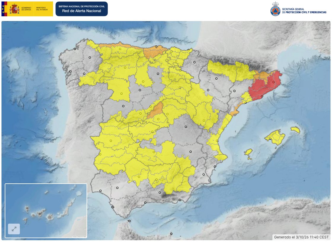
The author pointed out that there were orange warnings that day due to a strong maritime storm in the northern peninsula. He argued that news reports should explain the situation and give examples of how to act, and criticized exposing a reporter to danger. He added that meteorologists were tired of it. #Meteorología #AvisoNaranja #Temporal #ES (translated)

2712
Mar Gómez 1w

The author wrote that the Mediterranean region was one of the hot spots of climate change and that it was warming approximately 20% faster than the global average. He also noted that the waters of the Mediterranean were warming at a rate higher than the average of the oceans and deemed this fact fundamental. (translated)

3878
Mar Gómez 1w

The author warned that, as he wrote, the DANA Adam was entering its most dangerous hours and the Mediterranean was preparing for extraordinary rains. He also indicated that AEMET maintained red warnings in the southern coast of Valencia and the northern coast of Alicante, where up to 200 liters could accumulate. #DANA #clima #lluvias #ES #AD (translated)

3885
Mar Gómez 1w

The first thing we need to understand is that torrential rains are not a new phenomenon in Spain, although their intensity and frequency are becoming so. In this context, the meteorologist from eltiempo.es, Mar Gómez, agrees with the spokesperson from Aemet in explaining why the episodes of extreme rain occur. #CambioClimático #LluviasTorrenciales #CalentamientoGlobal (translated)

Las lluvias torrenciales, cada vez más intensas por el calentamiento del mar y la atmósfera: "Estamos en un nuevo clima"
www.20minutos.es
2629
Mar Gómez 2w

The author reported red alerts on the southern coast of Valencia and the northern part of Alicante, where, as he wrote, more than 300 mm could fall in some areas. He noted that the situation required maximum caution and presented a very high risk, and that heavy rains were expected in the rest of the Mediterranean region during Sunday and Monday. https://t.co/KVob8vHxD9 #Valencia #Alicante #FuertesLluvias #ES (translated)

3434
Mar Gómez 2w

The areas we must especially watch are the east of Catalonia, the surroundings of Cape Nao, the coasts of Alicante and Murcia, the Costa del Sol, and the Balearic Islands, especially the Pitiusas. "Sunday the 18th and Monday the 19th are shaping up to be the most adverse days," says Mar Gómez, meteorologist for eltiempo.es: "The areas we must especially watch are the east of Catalonia, the surroundings of Cape Nao, the coasts of Alicante and Murcia, the Costa del Sol, and the Balearic Islands, especially the Pitiusas. In some of these areas, accumulations of between 150 and 250 liters per square meter could be registered in a few hours, without ruling out higher amounts in localized areas," she notes. #Danas #LluviasTorrenciales #CambioClimático (translated)

Danas este fin de semana: ¿en qué zonas hay avisos por lluvias torrenciales?
www.elmundo.es
3094
Mar Gómez 3w

The author reported that a 7.7 magnitude earthquake shook Panama this Friday, causing evacuations, damage to buildings, and tsunami alerts in various points of the Pacific. He also located the epicenter near Pitaloza Arriba, in the central-southern part of the country. #Terremoto #Panamá #Últimahora #PA (translated)

3927
Mar Gómez 3w

The author urged to take extreme precautions in Baix Camp, Baix Ebre, Ribera d'Ebre, and Terra Alta due to intense rainfall, significant hail, and very strong wind gusts. He also noted that the storms had intensified again and mentioned the high temperature of the Mediterranean Sea and a significant influx. (translated)

3011
Mar Gómez 4w

The author urged to take extra precautions and warned that it would rain more in the coming hours, with a night of great risk and danger. He also noted that images like that were already starting to be seen. (translated)

1044
Mar Gómez 4w

The author warned that, in addition to rain, storms were expected on the coast of Barcelona, the southern coast of Girona, and the Ampurdán, with the possibility of hail and gusts of wind between 90 and 120 km/h. #Tormentas #Clima #Barcelona #ES (translated)

Mar Gómez 4w

The author pointed out that red warnings had been issued in Catalonia due to torrential rain, intense storms, and the risk of flooding. He also suggested that the situation could complicate between that night and Sunday and said he would explain the reasons. https://t.co/eKCMqDyd6S #Cataluña #Clima #Inundaciones #ES (translated)

348
Mar Gómez 4w

The author reported that a 102-year-old woman had died in her home and around 90 people had been rescued this Friday in Madrigueras (Albacete) after a flood that inundated the town. He also indicated that 142 liters of water had fallen per square meter in two and a half hours. #Madrigueras #Inundaciones #Albacete #ES (translated)

580
Mar Gómez 4w

⚠️ Complicated afternoon and night ahead in the Mediterranean. What will happen in the coming hours and why will there be even more intense rains? I'll tell you. 🧵 https://t.co/84qkRKb6mn #Mediterráneo #Lluvias #PronósticoMeteorológico #ES #IT #GR (translated)

1046
Mar Gómez 4w

🔴 What could happen in the next few hours? AEMET expects rainfall of up to 90 l/m² in one hour and accumulations of 250-300 l/m² in 12 hours in the most affected areas of the arch between Valencia, Castellón, and southern Tarragona. But some models see amounts that are even quite... https://t.co/U48UHMK0pd #Lluvias #AEMET #Clima #ES (translated)

349
Mar Gómez 4w

That's why the afternoon, night, and early morning are especially delicate. The episode will leave more torrential and persistent rains, with the capacity to cause rapid rises in streams, ravines, and low areas. Very, very dangerous hours are expected. (translated)

465
Mar Gómez 4w

The situation is becoming very dangerous and will worsen tonight. The amounts could be huge. Extreme caution because there will be more floods and rises. (translated)

930
Mar Gómez 4w

⚠️ Semana muy inestable en España: fuertes tormentas, posibles lluvias torrenciales y viento intenso. Una profunda borrasca atlántica marcará el tiempo entre martes y jueves, pero antes ya tendremos fuertes tormentas. Atención especialmente a Cataluña y este peninsular, donde https://t.co/WGnHHbpWFG #Tormentas #España #ClimaInestable #ES #Catalonia

815
Mar Gómez Sep 22

En apenas 24 horas, Polo ha pasado de tormenta tropical con vientos de 65 km/h y 1004 hPa a un huracán con 175 km/h y 964 hPa: +110 km/h de viento y una caída de 40 hPa en la presión central. La definición oficial de intensificación rápida es ganar al menos 55 km/h en 24 horas. https://t.co/uus9quXOIG #HuracánPolo #IntensificaciónRápida #Meteorología #Nospecificcountrycodescanbeidentifiedinthetweet.

Mar Gómez Sep 21

Así que cuando hablamos del futuro de las renovables no solo hay que pensar en cómo generar más energía limpia. También tenemos que preguntarnos: ¿cómo la guardamos para cuando realmente la necesitamos? #EnergíaRenovable #AlmacenamientoEnergía #FuturoSostenible #Nocountrycodesarepresentinthetweet.

Mar Gómez Sep 21

Ese depósito representa una reserva energética de unos 24 GWh. Para que os hagáis una idea esa energía equivaldría al consumo doméstico diario de 6,75 millones de personas. Es difícil imaginar una batería convencional de semejante escala escondida en una montaña. #EnergíaRenovable #Baterías #Sostenibilidad #Nocountrycodesarementionedinthetweet.